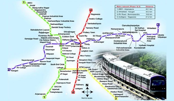
Bangalore Metro Route Map: Timings, Lines, and Stations
Navigating Bengaluru’s bustling streets becomes effortless with the Namma Metro. This comprehensive guide explores the Bangalore Metro Route Map, detailing...

Navigating Bengaluru’s bustling streets becomes effortless with the Namma Metro. This comprehensive guide explores the Bangalore Metro Route Map, detailing its lines, stations, and operational timings.
Overview of Namma Metro
Namma Metro, translating to “Our Metro” in Kannada, revolutionizes urban transportation in Bengaluru. Since its inception in 2011, it has provided a reliable, eco-friendly, and efficient commuting option, connecting key areas across the city.
Bangalore Metro Lines and Their Routes
Purple Line: East-West Corridor
The Purple Line stretches from Whitefield (Kadugodi) in the east to Challaghatta in the southwest, covering a distance of 43.49 kilometers. This line encompasses 37 stations, facilitating connectivity between residential, commercial, and industrial zones.
Key Stations on the Purple Line:
- Whitefield (Kadugodi): Serves the IT hub and residential communities.
- MG Road: Located in the heart of the city, known for shopping and entertainment.
- Kempegowda Majestic (Interchange): Major interchange connecting the Purple and Green Lines.
- Kengeri: Rapidly developing residential and commercial area.
Green Line: North-South Corridor
Extending from Nagasandra in the northwest to Silk Institute in the south, the Green Line spans 30.5 kilometers with 29 operational stations. Upon completion of Phase 2, it will expand to 34.46 kilometers with 32 stations.
Key Stations on the Green Line:
- Nagasandra: Proximity to Peenya Industrial Area.
- Yeshwanthpur: Near the railway station, facilitating easy transfers.
- Kempegowda Majestic (Interchange): Central hub connecting multiple transit systems.
- Jayanagar: Prominent residential and commercial locality.
Complete List of Bangalore Metro Stations
Purple Line Stations
- Whitefield (Kadugodi)
- MG Road
- Kempegowda Majestic (Interchange)
- Kengeri
For a detailed list of all 37 stations, please refer to the official Bangalore Metro resources.
Green Line Stations
- Nagasandra
- Yeshwanthpur
- Kempegowda Majestic (Interchange)
- Jayanagar
For a comprehensive list of all 29 operational stations, consult the Bangalore Metro’s official publications.
Bangalore Metro Timings
Weekday Operations:
- Start: 5:30 AM
- End: 11:00 PM
- Frequency: Trains arrive every 4-5 minutes during peak hours and every 10-15 minutes during non-peak hours.
Weekend Operations:
- Start: 6:00 AM
- End: 11:00 PM
- Frequency: Slightly reduced compared to weekdays.
Additional Benefits of the Bangalore Metro Route Map
Reducing Traffic Congestion
Bangalore Metro reduces daily traffic snarls significantly. Fewer cars on the road lead to smoother traffic flow, especially during rush hours. Metro commuters reach destinations faster and save precious time.
Encouraging Environmental Sustainability
Metro trains run on electricity, minimizing the carbon footprint compared to fossil-fueled vehicles. The Bangalore Metro supports a cleaner environment by offering a green mode of transit.
Facilitating Better City Planning
Urban planners now design developments around metro corridors. The metro attracts real estate growth, commercial hubs, and job creation. City expansion becomes more structured and sustainable.
Improving Last-Mile Connectivity
Feeder buses, shared autos, and cycle rental programs work alongside the metro. These services bridge the gap between stations and homes or workplaces, offering end-to-end convenience.
Future Expansions and Developments
Bangalore Metro’s expansion plans include several new lines and extensions aimed at enhancing city-wide connectivity.
Yellow Line
Connecting Rashtreeya Vidyalaya Road to Bommasandra, this 18.82-kilometer line with 16 stations is under construction and expected to be operational by February 2024.
Pink Line
Spanning 21.25 kilometers from Kalena Agrahara to Nagawara, the Pink Line will feature 18 stations. Its phased opening is anticipated between December 2024 and 2026.
Blue Line
Known as the ORR-Airport Metro Line, this 58.19-kilometer corridor will connect Central Silk Board to Kempegowda International Airport, comprising 30 stations. Completion is projected between June 2025 and June 2026.
Orange Line
Still in the planning stage, the Orange Line will extend approximately 80 kilometers, linking Kempapura to JP Nagar 4th Phase along the Outer Ring Road (ORR-West). Completion is targeted for 2028.
Tips for Using Bangalore Metro Efficiently
Download the Metro App
The official metro app provides real-time train schedules, fares, and route planning. Users avoid confusion and plan their journeys better.
Buy a Smart Card
Smart cards speed up entry and exit and save commuters from long ticket queues. Frequent travelers benefit most from this convenient option.
Avoid Peak Hours
Riding during non-peak times ensures a more comfortable journey. Passengers enjoy more seating space and quicker boarding.
Stay Updated with Announcements
Keep an eye on station announcements and digital boards. These provide timely updates about delays, construction work, or new train timings.
Conclusion
The Bangalore Metro Route Map significantly enhances urban mobility in Bengaluru, offering a dependable and eco-friendly transportation alternative. With ongoing expansions, Namma Metro is set to further improve connectivity, making daily commutes more efficient for residents and visitors alike.
For more information or assistance, feel free to contact us.
Frequently Asked Questions
1. What is the Bangalore Metro Route Map?
The Bangalore Metro Route Map shows the complete layout of Namma Metro’s network, including current lines, stations, and planned extensions.
2. How many metro lines operate in Bangalore?
Currently, two operational lines—Purple and Green—serve various city corridors. Future lines include Yellow, Pink, Blue, and Orange.
3. What time does Bangalore Metro service start and end?
Metro trains run from 5:30 AM to 11:00 PM on weekdays and from 6:00 AM to 11:00 PM on weekends.
4. Which station serves as the main interchange?
Kempegowda Majestic station serves as the central interchange between the Purple and Green Lines.
5. Can I travel from Whitefield to Majestic by metro?
Yes, the Purple Line directly connects Whitefield (Kadugodi) with Kempegowda Majestic.
6. Is the Bangalore Metro connected to the airport?
Currently, metro connectivity to Kempegowda International Airport is under construction through the Blue Line.
7. Are smart cards available for metro travel?
Yes, commuters can use smart cards for quicker, hassle-free entry and exit at metro stations.
8. Are there apps to check metro routes and timings?
The official metro app and various third-party apps help users check routes, timings, and train schedules in real-time.
9. Does the Bangalore Metro reduce city traffic?
Yes, the metro eases traffic congestion by encouraging people to switch from road transport to rail.
10. How can I stay updated on new metro lines and updates?
Stay informed through official metro announcements, their website, and local news updates.


