
48″ Aerial Targets: The Oversized Solution for High-Altitude Precision Mapping
In drone-based aerial surveying, optimal data-acquisition procedures seem to rest on one last pillar for accurate and reliable surface positioning....
In drone-based aerial surveying, optimal data-acquisition procedures seem to rest on one last pillar for accurate and reliable surface positioning. This precise positioning of the collected data is based on ground control. From construction or farming to overwhelmingly large expanses of land, aligning aerial imagery to real-world coordinates is indispensable. Such 48 inch aerial targets then offer the precision and visibility necessary for high-altitude drone mapping.
This article aims to make some important observations about why these oversized targets should be part of the toolkit of professionals. Especially those who demand reliable results while flying at higher altitudes or across very large areas.
What Are Aerial Targets?
Aerial targets, also known as ground control targets, are essential markers placed on the terrain to enable high-accuracy surveying with drones. These targets work alongside GPS coordinates to correct spatial distortions in aerial imagery, ensuring precise, geo-referenced maps for professional applications. While smaller targets suffice for low-altitude flights, they often struggle with visibility at higher elevations—especially in environments with poor contrast. This is where larger targets excel, as their enhanced size and high-contrast designs are critical for maintaining high-accuracy surveying standards across varying altitudes and terrains.
Why Size Matters in High-Altitude Mapping
As drones operate from ever-greater altitudes to record images covering wide areas, the distinctness of ground markers poses yet another challenge. A common-sized target may not be sharp enough for the imaging-processing software to set its position correctly. This results in misalignment and degraded accuracy. Large targets, especially those 48 inches in diameter, will still be well-defined from altitudes of 400 feet and more.
The increased area, therefore, enables:
- Better recognition in raw aerial imagery.
- Faster recognition by automated software.
- More accurate pinpointing of GPS coordinates.
In a word, 48″ aerial targets provide absolutely clear visual “tie-points” to facilitate assembling large sets of photographs into seamless, accurate maps.
Ideal Use Cases for Oversized Targets
Large ground control points are not required for every mapping project, but many scenarios benefit from enhanced visibility and precision.
1. High-Altitude Flights:
When carrying out drone mapping, operators working at altitudes of 300 feet or more rely on larger targets for accuracy. Otherwise, the readings are prone to being blurry or distorted.
2. Wide-Area Mapping:
Projects that cover large parcels of land, such as farms, industrial sites, or land-development areas, need concrete reference points. That is observable from a distance to maintain spatial accuracy.
3. Harsh Surface Conditions:
On surfaces where small targets might blend in, such as gravel, concrete, or dry grass, larger targets offer higher contrast, making for easy spotting when viewed from imaging.
4. Surveying with RTK/PPK Drones:
Despite potentially in-play RTK or PPK systems, visual ground targets can really serve as a second layer of verification. Oversized targets are practical alternatives or additional control points.
Features That Make 48″ Targets Stand Out
Large aerial targets must fulfill many roles beyond their size. They should be robust enough to withstand inclement conditions and yet lightweight and compact enough. This is useful as they are accurate enough to be portable and compatible with mapping software. Typically, top-of-the-line models fulfill the following:
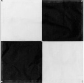
- High-Contrast Designs: Most 48-inch targets are patterned “checker” or “bull’s eye” in black and white so that the image is easily perceived.
- UV-Resistant Material: This offers an elongated life for fabric and, therefore, targets under glaring sunlight with minimum fading.
- Weighted Corners or Stakes: These keep the target lying flat and stable, even in gusty wind.
- Foldable and Portable: Despite their size, most big targets can conveniently be folded or rolled up for transport.
- Weather Resistant: The target can survive a variety of weather conditions, such as rain, dust, and extreme heat.
In order to maximize results, proper placement becomes critical.
In the case of large aerial targets, placement becomes paramount in securing their optimal and functional potential. Spacing the targets evenly anywhere on the field would also serve to enhance mapping accuracy. Targets need to be placed flat and in clear view, preferably far away from obstructions like trees or buildings.
Tips for successful deployment:
- Use GPS to log exact site coordinates for each target.
- Position at least five targets through large survey areas for proper coverage balance.
- The targets should have good contrast with the background surface.
When employed right, even a small number of well-placed targets can significantly improve mapping quality.
Balancing Size with Convenience
One concern with oversized targets is whether they are harder to handle or will take longer to set up. But many professional-grade 48″ aerial targets are specifically designed to be light, collapsible, and easy to deploy.
Conclusion
Drone mapping has transformed the way we gather spatial data. But technology alone is insufficient- it is only as good as on-ground reference points. Large-format ground control markers provide clarity and scale. This is needed for high-altitude projects in which attention to detail matters, and 48″ aerial targets are among them.
These oversized solutions are simple but powerful upgrades for those mapping vast exposure or surveying from elevated positions. They are wise for professionals who observe accuracy, reliability, and professionalism in their mapping work.